Lake Judd Walk

Lake Judd Walk

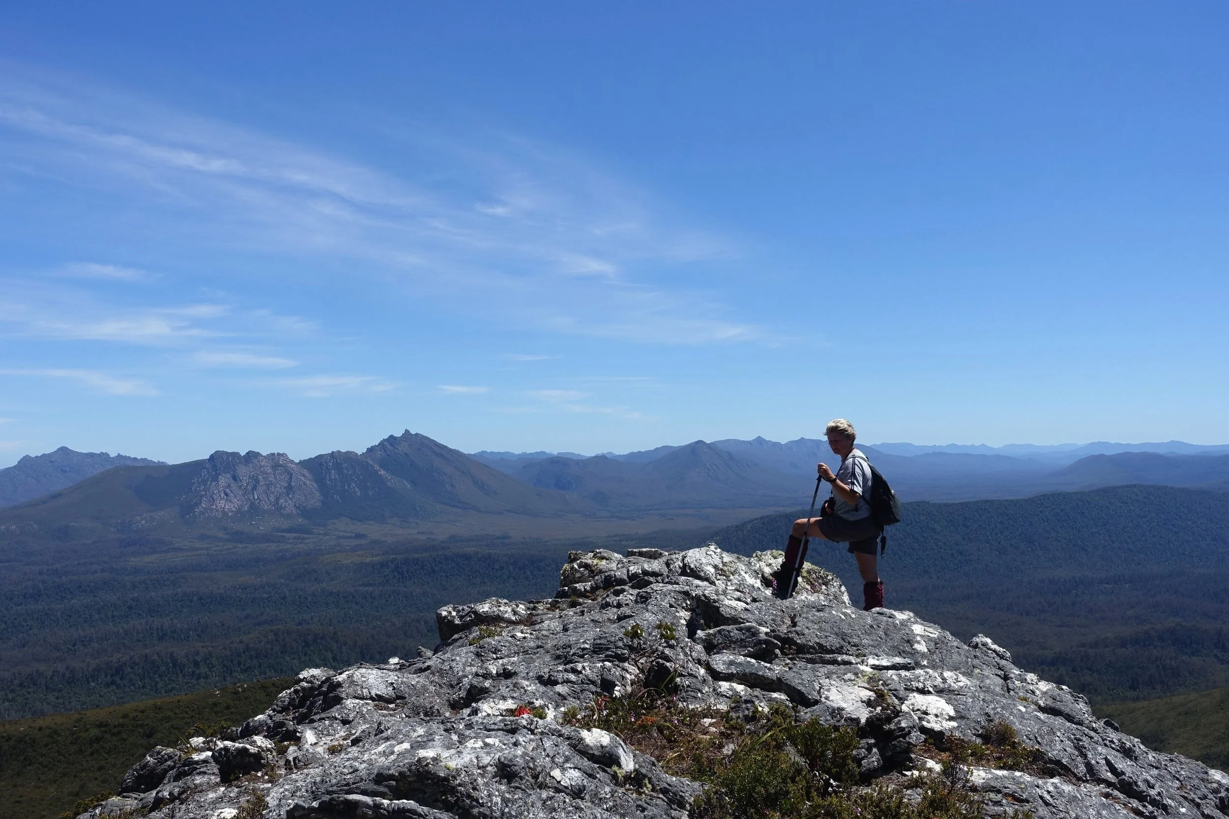
Lake Judd is an ancient glacier-formed lake in Tasmania’s Southwest National Park, with a spectacular back-drop of 600 metre high cliffs and views of Mt Anne, SW Tasmania’s highest peak. The 16 km day walk to the lake and back traverses button grass plains peppered with pink quartzite outcrops. As the track ascends the view behind is of Lake Pedder and surrounding peaks. The first 7 kms of the 8 kms to the lake is on part of the renowned, multi-day Mt Anne Circuit Walk.  We did the Lake Judd walk in January 2024. Here’s what we found.

Read More

Mount Kate Walk - Cradle Mountain

Mount Kate Walk - Cradle Mountain

Mount Kate is a little visited peak in the Cradle Mountain – Lake St Clair National Park. It is not signposted but is a relatively easy 6 km return walk from Ronny Creek. It provides great views of Cradle Mountain, with a different perspective to most of the walking tracks in the area. It is a very worthwhile day walk. Here’s how we went about it.

Read More

Arthur River to Sundown Point Walk

Arthur River to Sundown Point Walk

Starting from the evocatively named ‘Edge of the World’, at the mouth of the Arthur River on Tasmania’s wild west coast, this beach walk takes you along a stretch of broad, white sand to a rocky point of great significance to Tasmania’s indigenous peoples. It’s an easy half day (4 – 5 hour) walk that gives a good feel for this dramatic, windswept coastline facing the Roaring Forties and the Southern Ocean.

Read More

Return to Shippies - Shipstern Bluff Walk

Return to Shippies - Shipstern Bluff Walk

In November 2017 we published a post describing the day walk to the famous southern Tasmanian big wave surfing spot of Shipstern Bluff aka Shippies. Four years on we’ve returned to Shippies to check out the upgrades to the walk that we’d heard had been done. This post describes these changes. The walk itself still takes four hours return following the same track. But there have been some nice improvements to amenities and signage in the intervening years.

Read More

Cape Surville Walk (With a Little Help From an E-Bike)

Cape Surville Walk (With a Little Help From an E-Bike)

Cape Surville is a little visited, but spectacular location on the Forestier Peninsula, on Tasmania’s east coast. A return walk of just under 6 kms features some dramatic high sea cliffs. The access road in is rough in parts and requires a four-wheel drive vehicle. We didn’t have one, but solved this problem by cycling the most difficult section on e-mountain bikes (EMTBs). Here’s how we did it.

Read More

Black Glen Falls Walk

Black Glen Falls Walk

Black Glen Falls is a series of five small waterfalls on the Lachlan River in southeast Tasmania. It sits inside Wellington Park, the reserve that covers most of kunanyi/Mt Wellington. The walk to the falls and back is a 4 kilometre return trip. Despite being less than an hour’s drive from home in Hobart I’d never been there before, so with regular walking companion Graeme, we went to check it out.

Read More

The Growling Swallet

The Growling Swallet

A “swallet’ is defined as an “underground stream”, also “an opening through which a stream disappears underground”. Tucked away in a corner of Mt Field National Park in Southern Tasmania is Growling Swallet. It is a place where the Junee River disappears underground through a large cave. It is said that when the river is running hard it positively growls. I’d never heard of this place until recently when a friend mentioned it. We decided to check it out. Here’s what we found.

Read More

Four Dog-Friendly Walks in North East Tasmania

Four Dog-Friendly Walks in North East Tasmania

Being the proud owners of Frida, the heeler-border collie cross rescue dog, means that walks in national parks are off the menu when we want to take Frida with us. North East Tasmania doesn’t have a lot of territory classified as national parks, but it does have plenty of good, short walks within reserves and state forests where dogs are permitted. We decided to check out a few of these. Here are four good dog-friendly short walks in the region.

Read More

Waratah - A Tale of Three Waterfalls

Waratah - A Tale of Three Waterfalls

Waratah is a small town in North West Tasmania. The town was built to support a tin mine at nearby Mt Bischoff. It was constructed on top of a waterfall so that the diverted water could be used for mining operations. On my recent first-time visit to Waratah, I was keen to see the town waterfall. While there we took the opportunity to visit two other waterfalls in the area and a couple of other sites of interest.

Read More

Richmond Heritage Walk

Richmond Heritage Walk

The township of Richmond is one of Tasmania’s oldest settlements. Richmond was a convict station and military post. It is home to Australia’s oldest bridge built in 1823 by convicts. Just thirty minutes’ drive from the centre of Hobart, Richmond is an excellent day trip for anyone visiting the south of the state. In this post we describe the Richmond Heritage Walk as recommended by Clarence Council which we did recently.

Read More

Cremorne to Roches Beach Walk

Cremorne to Roches Beach Walk

The Clarence Coastal Trail makes it possible to walk from Cremorne to Seven Mile Beach, a distance of around 13.5kms. It is an attractive and satisfying walk. You can leave or join at several places or just do a chosen section. We have broken the walk down into two sections: Cremorne to Roches Beach (this post) and Roches Beach to Seven Mile Beach (previous post).. Read on if you want to know more.

Read More

Nierinna Creek and Margate Creek Tracks, Southern Tasmania

Nierinna Creek and Margate Creek Tracks, Southern Tasmania

In the southern suburbs of Hobart lies the municipality of Kingborough. Within this region there are an abundance of walking opportunities, including a lot of good short walks. Along with friend Jillian I decided to combine two creek walks which we had not previously done – Nierinna Creek Track and Margate Creek Track. The walk notes and maps on the council web page showed how these two walks could be easily joined into one longer walk.

Read More

Hobart Rivulet Walk

Hobart Rivulet Walk

The Hobart Rivulet was critically important to 19th century colonial Hobart both as it’s water supply and for a number of industrial purposes. Today the 2.7 km walk beside the rivulet which wends through the suburb of South Hobart provides many insights into the city’s past. It also affords excellent views of kunanyi/Mt Wellington before concluding at the Cascade Brewery, Australia’s oldest brewery, established 1824.

Read More

Historic Kelly Basin Walk

Historic Kelly Basin Walk

Kelly Basin is on the south east side of Macquarie Harbour on Tasmania’s west coast. The towns of East and West Pillinger once stood on Kelly Basin and had a population of over 1000. East Pillinger was established as a port for the North Mount Lyell Mining Company’s rail line which ran from Queenstown bringing copper to be exported.. The town was abandoned in 1924 after the rival Mount Lyell Mining Company took over North Mount Lyell Mining. Today there are still remnants of the port town of East Pillinger to be explored. This includes brick kilns, parts of buildings, giant metal boilers and the old wharf. We wanted to see for ourselves so headed off from Queenstown to do the half day walk.

Read More

Two Walks in the Tarkine

Two Walks in the Tarkine

The term Tarkine or takayna, its Aboriginal name, is used to describe much of north west Tasmania. It is a region of rainforests and rivers, imposing mountains and wild coastlines. It is currently unprotected. There are ongoing efforts by many people to have this remedied to protect the area for future generations. With regular walking companion Graeme, we chose two walks in the southern part of the Tarkine – the Huskisson River Rainforest Walk and Mt Murchison, one of the west’s highest peaks.

Read More

Secret Tasmania: Clydes Island and Beyond

Secret Tasmania: Clydes Island and Beyond

Many visitors to the Tasman Peninsula, on their way to the Port Arthur Historic Site, make a brief stopover at the Tessellated Pavement State Reserve at Eaglehawk Neck. They come to admire the unusual, geometric patterns in the coastal rock platform. From the Tessellated Pavement the view to the north features a small island adjacent to the shore. This is Clydes Island. Few bother to make the leisurely one kilometre walk along the beach and rocky shoreline to the island. We decided to have a closer look at Clydes Island and then to venture along the cliff-top trail that we’d heard continues beyond.

Read More

The Needles - One of Tasmania's Most Spectacular Short Wilderness Walks

The Needles - One of Tasmania's Most Spectacular Short Wilderness Walks

The Needles are a group of rocky spires that protrude from the landscape of south west Tasmania. The 2 – 3 hour return walk to the top-most Needle (1020m) takes you up a steepish trail with spectacular views unfolding as you ascend. From the top you have a 360 degree panorama of the SW Wilderness World Heritage Area. On a clear day this has to be one of Tassie’s most spectacular short wilderness walks.

Read More

Cape Raoul - The Third Cape

Cape Raoul - The Third Cape

When you book the Three Capes Track 4 day walk, in SE Tasmania, you are actually only getting two capes for your money – Cape Pillar and Cape Hauy. This isn’t to say that it isn’t a fabulous experience – it is. The trail takes you along some of Australia’s most spectacular coast and cliffs. But if you want your full complement of capes then you need do a separate additional day walk to nearby Cape Raoul. This post describes our recent visit to Cape Raoul, our first since new track work was done.

Read More

Secret Tasmania - Bluff Canyon

Secret Tasmania - Bluff Canyon

Tasmania is full of places and attractions that don’t feature prominently in the tourist literature. In fact, some are so obscure that many locals don’t even know about them. This post describes a day walk we did to little known Bluff Canyon. In the spirit of Secret Tasmania, we don’t give too much detail about where and how to do the walk. There are no maps here. If you’re interested, you might need to do a bit of extra research.

Read More

Monk Bay Circuit Walk (Incorporating Historic Convict Coal Mines)

Monk Bay Circuit Walk (Incorporating Historic Convict Coal Mines)

The Monk Bay Circuit Walk is a 8.3km coastal walk within the Lime Bay State Reserve, Tasman Peninsula in south east Tasmania. It’s an easy 3 – 3.5 hour walk with constant views of the surrounding waterways.

The Tasman Peninsula is also home to the Port Arthur Historic Site, Australia’s premier colonial convict site. Close to Port Arthur are the remains of a large convict probation station established for the purposes of coal mining. Today there are well preserved ruins with good interpretative signs. The Historic Coal Mines site can easily be combined with the Monk Bay walk making for a varied and interesting day trip from Hobart. And it’s all free.

Read More